
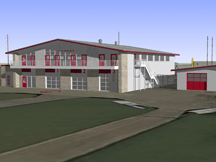
Big Room for Big Red
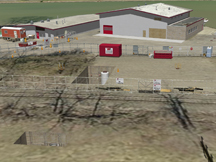
Room to Row
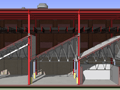
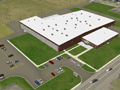
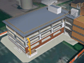
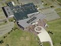
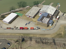
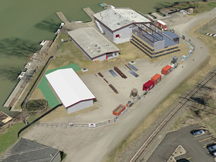
A university wants to expand an athletic facility on the lakeshore’s placid waters. The interview is two weeks off, and we need to move. Bid documents are available which describe the facility, modest by most of Vinci’s recent work, but important both to the client and the University. The site sits low in relation to the lake, where lakeside access roads snake between University property and those of neighboring businesses. Care must be taken not to block access to other facilities, and to mind the utilities underground.
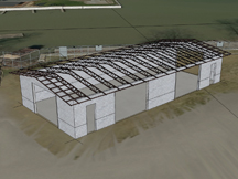
Validate construction strategy vs. site constraints
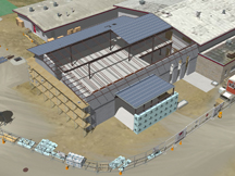
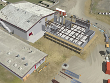
Vinci pulls down geodata and produces a VinTerra™ digital model of terrain at four inch per pixel resolution. Significant context is modeled and the subject, an annex, an ancillary storage building, sitework, and retrofits are produced shortly afterward. Vinci rapidly processes plan data so that the models of proposed and significant existing structures are drawn accurately and efficiently. At about 40% complete, the project is held given the University’s two-week postponement of the deadline. Once the project restarts, Vinci receives directives enabling completion of the work. Vinci’s Digital Worksite™ service furnishes enough resolution to allow some quick strategy validation. It’s easy to overestimate circulation space on a given set of plans. Since all significant constraints are present in the Digital Worksite™, it’s easy to check phasing against constraints to ensure we’re “out of the way” of any enabling work and circulation to the other facilities.
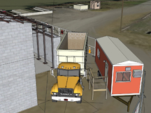
See the unseen and respond to it
Vinci’s unique SubVision™ capabilities place underground constraints on your worksite so that you can prove you aren’t strangling utilities. SubVision Xray™ is sufficient for most projects that call for underground references. Sometimes you need something more robust. Given adequate data, Vinci can produce limited SubVision Solid™ renditions of enabling work or site utilities. Many folks rely on Internet-available geodata to convey context. These datasets are coarse and sometimes need “help” to effectively portray site conditions. Vinci VinTerra™ expertly amends any orthoaerial photograph through Vinci ClearSite™, provided data exists, so you can see your worksite as it actually exists, not as the search engine thinks it exists. Clinch that job with clear, convincing, and audience-friendly construction marketing visualization from Vinci LLC!
This page last modified Wednesday 16 November 2011.